gldas

Readers and converters for data from the GLDAS Noah Land Surface Model. Written in Python.
Works great in combination with pytesmo.
Citation
If you use the software in a publication then please cite it using the Zenodo DOI. Be aware that this badge links to the latest package version.
Please select your specific version at https://doi.org/10.5281/zenodo.596427 to get the DOI of that version. You should normally always use the DOI for the specific version of your record in citations. This is to ensure that other researchers can access the exact research artefact you used for reproducibility.
You can find additional information regarding DOI versioning at http://help.zenodo.org/#versioning
Installation
Setup of a complete environment with conda can be performed using the following commands:
conda create -n gldas python=3.6 # or any other supported python version
source activate gldas
# Either install required conda packages manually
conda install -c conda-forge numpy netCDF4 pyproj pygrib
# Or use the provided environment file to install all dependencies
conda env update -f environment.yml
# Install the gldas package and pip-dependencies
pip install gldas
This will also try to install pygrib for reading the GLDAS grib files. If this does not work then please consult the pygrib manual.
Supported Products
At the moment this package supports GLDAS Noah data version 1 in grib format (reading, time series creation) and GLDAS Noah data version 2.0 and version 2.1 in netCDF format (download, reading, time series creation) with a spatial sampling of 0.25 degrees. It should be easy to extend the package to support other GLDAS based products. This will be done as need arises.
Downloading Products
In order to download GLDAS NOAH products you have to register an account with NASA’s Earthdata portal. Instructions can be found here.
After that you can use the command line program gldas_download.
mkdir ~/workspace/gldas_data
gldas_download ~/workspace/gldas_data
would download GLDAS Noah version 2.0 in 0.25 degree sampling into the folder
~/workspace/gldas_data. For more options run gldas_download -h.
Contribute
We are happy if you want to contribute. Please raise an issue explaining what is missing or if you find a bug. We will also gladly accept pull requests against our master branch for new features or bug fixes.
Development setup
For Development we also recommend a conda environment. You can create one
including test dependencies and debugger by running
conda env create -f environment.yml. This will create a new gldas
environment which you can activate by using source activate gldas.
Guidelines
If you want to contribute please follow these steps:
- Fork the gldas repository to your account
- Clone the repository, make sure you use
git clone --recursiveto also get the test data repository. - make a new feature branch from the gldas master branch
- Add your feature
- Please include tests for your contributions in one of the test directories. We use py.test so a simple function called test_my_feature is enough
- submit a pull request to our master branch
Note
This project has been set up using PyScaffold 2.5.6. For details and usage information on PyScaffold see http://pyscaffold.readthedocs.org/.
Reading GLDAS images
Reading of the GLDAS raw grib files can be done in two ways.
Reading by file name
import os
from datetime import datetime
from gldas.interface import GLDAS_Noah_v1_025Img

# read several parameters
parameter = ['086_L2', '086_L1', '085_L1', '138', '132', '051']
# the class is initialized with the exact filename.
img = GLDAS_Noah_v1_025Img(os.path.join(os.path.dirname(__file__),
                                        'test-data',
                                        'GLDAS_NOAH_image_data',
                                        '2015',
                                        '001',
                                        'GLDAS_NOAH025SUBP_3H.A2015001.0000.001.2015037193230.grb'),
                          parameter=parameter)

# reading returns an image object which contains a data dictionary
# with one array per parameter. The returned data is a global 0.25 degree
# image/array.
image = img.read()

assert image.data['086_L1'].shape == (720, 1440)
assert image.lon[0, 0] == -179.875
assert image.lon[0, 1439] == 179.875
assert image.lat[0, 0] == 89.875
assert image.lat[719, 0] == -89.875
assert sorted(image.data.keys()) == sorted(parameter)
assert image.data['086_L1'][26, 609] == 30.7344
assert image.data['086_L2'][26, 609] == 93.138
assert image.data['085_L1'][576, 440] == 285.19
assert image.data['138'][26, 609] == 237.27
assert image.data['051'][26, 609] == 0
assert image.lon.shape == (720, 1440)
assert image.lon.shape == image.lat.shape
Reading by date
All the gldas data in a directory structure can be accessed by date. The filename is automatically built from the given date.
from gldas.interface import GLDAS_Noah_v1_025Ds

parameter = ['086_L2', '086_L1', '085_L1', '138', '132', '051']
img = GLDAS_Noah_v1_025Ds(data_path=os.path.join(os.path.dirname(__file__),
                                                'test-data',
                                                'GLDAS_NOAH_image_data'),
                          parameter=parameter)

image = img.read(datetime(2015, 1, 1, 0))
For reading all image between two dates the
gldas.interface.GLDAS_Noah_v1_025Ds.iter_images() iterator can be
used.
Variable naming for different versions of GLDAS NOAH
For GLDAS Noah 1.0 parameters are called using their PDS IDs from the table below. A full list of PDS IDs can be found in the GLDAS 1.0 README
For GLDAS Noah 2.0 and GLDAS Noah 2.1 parameters are called using Variable Names from the table below. A full list of variable names can be found in the GLDAS 2.x README
| PDS ID (old) | Variable Name (new) | Parameter | Resolution | Depth/Height Interval [m] | Units |
|---|---|---|---|---|---|
| 086_L1 | SoilMoi0_10cm_inst | Soil moisture | 0.25° | 0.00 - 0.10 | [kg/m^2] |
| 086_L2 | SoilMoi10_40cm_inst | Soil moisture | 0.25° | 0.10 - 0.40 | [kg/m^2] |
| 086_L3 | SoilMoi40_100cm_inst | Soil moisture | 0.25° | 0.40 - 1.00 | [kg/m^2] |
| 086_L4 | SoilMoi100_200cm_inst | Soil moisture | 0.25° | 1.00 - 2.00 | [kg/m^2] |
| 085_L1 | SoilTMP0_10cm_inst | Soil temperature | 0.25° | 0.00 - 0.10 | [K] |
| 085_L2 | SoilTMP10_40cm_inst | Soil temperature | 0.25° | 0.10 - 0.40 | [K] |
| 085_L3 | SoilTMP40_100cm_inst | Soil temperature | 0.25° | 0.40 - 1.00 | [K] |
| 085_L4 | SoilTMP100_200cm_inst | Soil temperature | 0.25° | 1.00 - 2.00 | [K] |
| 065 | SWE_inst | Snow depth water equivalent | 0.25° | 0 | [kg/m^2] |
| 138 | AvgSurfT_inst | Average Surface Skin temperature | 0.25° | 0 | [K] |
| 131 | Snowf_tavg | Snow precipitation rate | 0.25° | 0 | [kg/m^2/s] |
| 132 | Rainf_tavg | Rain precipitation rate | 0.25° | 0 | [kg/m^2/s] |
| 057 | Evap_tavg | Total Evapo-transpiration | 0.25° | 0 | [kg/m^2/s] |
Conversion to time series format
For a lot of applications it is favorable to convert the image based format into a format which is optimized for fast time series retrieval. This is what we often need for e.g. validation studies. This can be done by stacking the images into a netCDF file and choosing the correct chunk sizes or a lot of other methods. We have chosen to do it in the following way:
Store only the reduced gaußian grid points since that saves space.
Further reduction the amount of stored data by saving only land points if selected.
Store the time series in netCDF4 in the Climate and Forecast convention Orthogonal multidimensional array representation
Store the time series in 5x5 degree cells. This means there will be 2566 cell files (without reduction to land points) and a file called
grid.ncwhich contains the information about which grid point is stored in which file. This allows us to read a whole 5x5 degree area into memory and iterate over the time series quickly.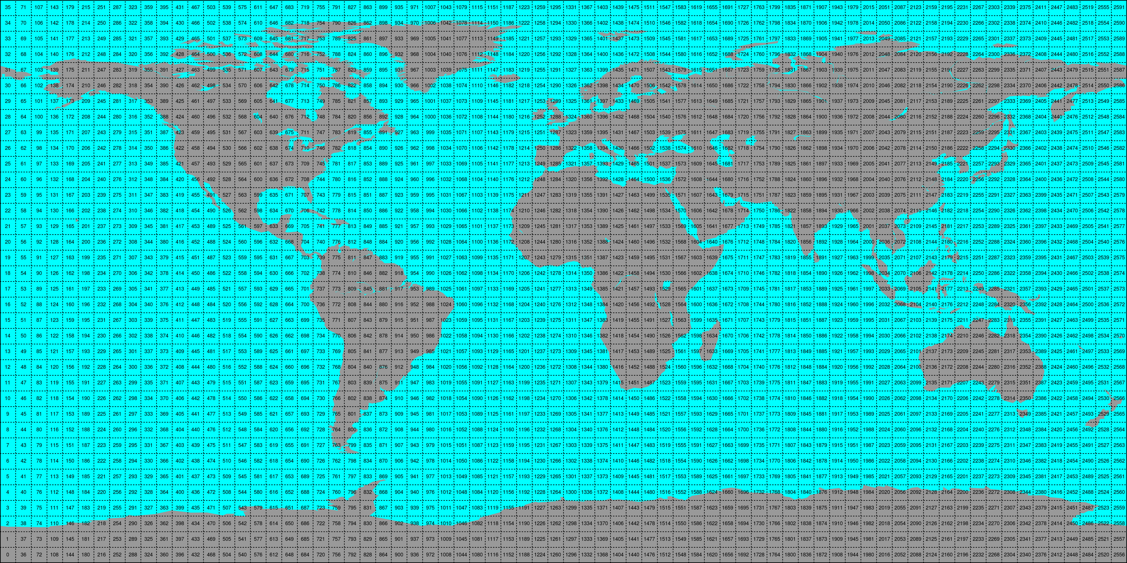
This conversion can be performed using the gldas_repurpose command line
program. An example would be:
gldas_repurpose /gldas_data /timeseries/data 2000-01-01 2001-01-01 SoilMoi0_10cm_inst SoilMoi10_40cm_inst
Which would take GLDAS Noah data stored in /gldas_data from January 1st
2000 to January 1st 2001 and store the parameters for the top 2 layers of soil moisture as time
series in the folder /timeseries/data.
Conversion to time series is performed by the repurpose package in the background. For custom settings
or other options see the repurpose documentation and the code in
gldas.reshuffle.
Note: If a RuntimeError: NetCDF: Bad chunk sizes. appears during reshuffling, consider downgrading the
netcdf4 library via:
conda install -c conda-forge netcdf4=1.2.2
Reading converted time series data
For reading the data the gldas_repurpose command produces the class
GLDASTs can be used:
from gldas.interface import GLDASTs
ds = GLDASTs(ts_path)
# read_ts takes either lon, lat coordinates or a grid point indices.
# and returns a pandas.DataFrame
ts = ds.read_ts(45, 15)